GIS Lab
The GIS Lab provides researchers and students with GIS advice and support at the University of Amsterdam. Its team is involved in the GIS education programme, providing undergraduate and graduate GIS courses from introductory to advanced levels. The researchers in the team are involved in cutting-edge GIS research within the social sciences domain. The research mission is to apply a spatial angle and incorporate spatial analysis tools to fundamental questions of human geography, planning and international development, as well themes across the social sciences more broadly. The GIS Lab members are further involved in research proposals and carrying out acquired research grants.
The support staff of the GIS Lab provide advice and support to researchers across the Faculty of Social and Behavioural Scienced (FMG). For both research staff and students, the GIS Lab team supports requests regarding various GIS-related inquiries and access to software and hardware resources.
GIS Lab Services
The GIS Lab provides key services for GIS research and education. Some key services are listed below. If you would like to inquire about these, please get in touch with the GIS Lab’s contact-person, Marcel Heemskerk.
GIS research and technical advice
The GIS Lab provides research and technical advice for researchers across the FMG using, or interested in using, GIS methods. Staff working with GIS can contact us for advice. We are happy to meet and discuss opportunities for integrating GIS into your research, albeit our potential engagement is, of course, dependent on time availability.
GIS Power Computer
The GIS Lab hosts a state-of-the-art computer with powerful computing and visualization capabilities that is available to all staff. This computer can be used for analysis and visualization of data that require higher processing capacity. To arrange to use the GIS Power Computer, simply contact Marcel Heemskerk to book it and check availability.
GIS computer lab
The GIS Lab provides a computer lab for GIS analysis which is accessible to all FMG researchers and students using GIS. It is located in the L-building of the Roeterseiland campus and is equipped with essential infrastructure for GIS analysis, including 12 high-performing double-screen computers. Computers are equipped with all the common GIS software: including ArcGIS Pro and QGIS.
Supported GIS computer lab hours
Two days a week, Marcel Heemskerk is available for GIS support for users of the GIS computer lab. Depending on time constraints, he is available for general advice on different GIS approaches and help with technical troubleshooting. His availability is listed below (under Contact & Office Hours). Where these hours differ or his availability is limited, times will be posted on his office door: Room L.207A located adjacent to the GIS Lab.
GIS software and licencing
The GIS Lab provides access to the ESRI ArcGIS suite of spatial analysis software for researchers as well as students across the Faculty of Social and Behavioural Sciences (FMG).
Staff members can install ArcGIS Pro on their laptops through the UvA Software Center. Students can download and install the software on their own laptops. In both cases, an ArcGIS Online account is required. You can request an account and obtain installation instructions from Marcel Heemskerk at M.J.Heemskerk@uva.nl.
Please include the following information in your request: First name, Last name, Student ID, UvA email address.
Plotter
The GIS Lab provides plotting services for colour printing up to A0 poster size. For printing with the A0 plotter, please contact Marcel Heemskerk. You should email your file for printing a week in advance to ensure it can be processed in time and taking into account Marcel Heemskerk’s working days.
Other hardware
The GIS Lab also has several other hardware available for researchers and students, such as GPS Locators for data collection and a scanner for digitization of paper material.
StoryMaps
The GIS Lab provides hosting of ESRI ‘StoryMaps’ which are an online multimedia website that includes interactive GIS mapping. These are a nice way to showcase and share spatial research output in an approachable and engaging way. They are currently also being used for student projects in GIS courses.
GIS online data & self-study Resources
See the Teaching & Resources page for manuals for common GIS analysis methods that we offer for self-study. Additionally, we provide on the page a list of valuable online spatial data resources relevant to the social sciences.
GIS teaching & training
The GIS Lab supports the GIS teaching programme within the Department of Geography, Planning and International Development Studies with courses within the Bachelors and Masters level. The GIS Lab organizes short intensive classes for staff. These intensive classes are promoted through email and newsletters and held in the GIS computer room. Our resources for self-study also present a useful place to start.
Contact & Office Hours
Where to find us?
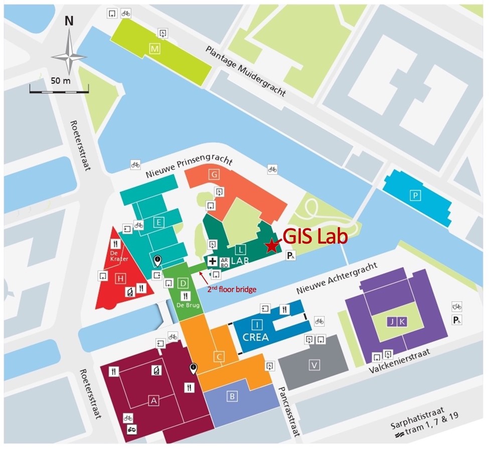
The GIS Lab is located on the second floor of the L-building at Roeterseiland Campus in Room L2.07 (computer lab room) and L2.07A (support office and GIS Power Computer).
The L-building can be reached both directly from outside or via a bridge link from the second floor of the D-building. For example, from the B/C buildings, you simply need to cross De Brug, go to the second floor of the D-building and the connecting bridge is located behind the elevators. After crossing the bridge into the L-building, the GIS Lab is simply straight through at the end of the hallway on the same floor. The map below shows the location of the L-building, the GIS Lab and the bridge link.
In person drop-in hours
For standard inquiries please get in touch with Marcel Heemskerk, the GIS Lab contact-person and technical officer.
Marcel Heemskerk works at the GIS Lab two days a week on Mondays and Tuesdays. The rest of GIS Lab team is listed under the People page.
Besides inquiries via email, Marcel Heemskerk maintains the following office hours during his workdays when he is usually available for drop-in inquiries.
His office is located next to the GIS computer room in the L building (L2.07).
- Mondays: 9:00 – 17:00
- Tuesdays: 9:00 – 17:00